
চিত্র:1776 Rennell - Dury Wall Map of Bihar and Bengal, India - Geographicus - BaharBengal-dury-1776.jpg

মূল ফাইল (৯,১০৬ × ৬,০০০ পিক্সেল, ফাইলের আকার: ১৬.৮৬ মেগাবাইট, এমআইএমই ধরন: image/jpeg)
| এই ফাইলটি উইকিমিডিয়া কমন্স থেকে নেওয়া। সেখানের বর্ণনা পাতার বিস্তারিত নিম্নে দেখানো হলো। (সম্পাদনা)
|
সারাংশ
| সতর্কীকরণ | মূল ফাইলে বড় সংখ্যার পিক্সেল আছে এবং এটি সঠিকভাবে লোড নাও হতে পারে বা আপনার ব্রাউজার নিশ্চল করে দিতে। |
|---|
| শিরোনাম |
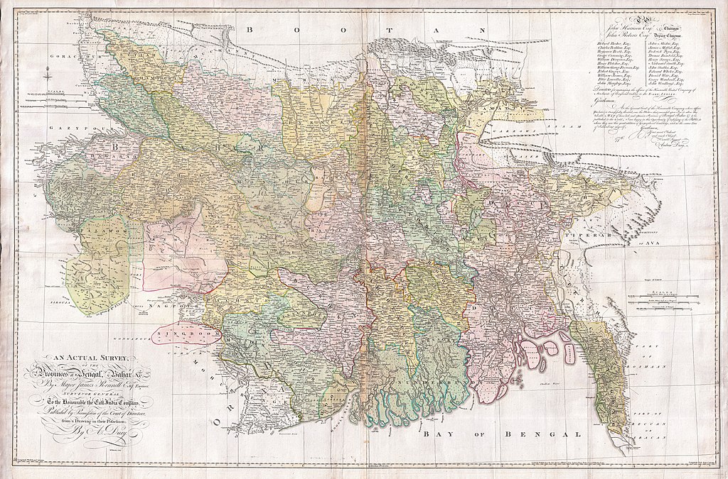
An Actual Survey, of the Provinces of Bengal, Bahar & c. by Major James Rennell Esq. Engineer to the Honorable the East India Company. Published by Permission of the Court of Directors from a Drawing in their Possession by A. Dury. |
|||||||||
| বর্ণনা |
English: An altogether spectacular wall sized map of those parts of Bengal and Bihar, India. Follows the course of the Ganges River from Varanasi (Benares) eastward to the Ganges Delta and the Bay of Bengal. Includes Varanasi (Benares), Dacca (Dahka, Bengladesh), and Patna among many other important Indian cities. Bounded on the north by the Himalaya Mountains and the border with Bhutan. One of the first accurate maps of the interior of India. Laid out from primary surveys done by James Rennell, the first modern cartographer to map the interior of India. Notes cities, markets, battlefields, fortresses, roads, rivers, offers political commentary, and features some geographical references. Elaborate title in the lower left quadrant. Upper right quadrant features a dedication and letter of thanks written by Andrew Dury, the publisher, to the board of the East India Company. This is the first edition of this rare map – 1776 – as published by Dury. Later editions were published by Sayer and Bennet and by Laurie and Whittle.
Another high quality digitisation is available at the David Rumsey Historical Map Collection: [1] This map was published by Laurie and Whittle, as mentioned in the description by Geographicus for the 1776 map, in 1794. Regions are demarcated in coloured outlines instead of filled colours. A higher quality digitisation than that of Geographicus. Contains parts that are missing at the central vertical fold in the Geographicus digitisation of the 1776 map. Viewable in online Flash viewer and downloadable in MrSID format. |
|||||||||
| তারিখ | (dated) | |||||||||
| উৎস |
The Bengal Atlas ??, Rennell, James, (1779 first edition)
|
|||||||||
| স্রষ্টা | ||||||||||
| Geotemporal data | ||||||||||
| ভৌগলিক সীমা |
|
|||||||||
| Warper-এ মানচিত্রের আস্তরণ | ||||||||||
| Archival data | ||||||||||
| সংযোজন সংখ্যা |
Geographicus link: BaharBengal-dury-1776 |
|||||||||
| আকার | উচ্চতা: ৩৯.০ ইঞ্চি (৯৯.০ সে.মি.); প্রস্থ: ৫৯.০ ইঞ্চি (১৪৯.৮ সে.মি.) | |||||||||

|
এই ছবিটিকে মূল্যবান চিত্রের মানদণ্ড অনুযায়ী মূল্যায়ন করা হয়েছে এবং এটিকে: Old maps of Bengal from 1776 by Major James Rennell পরিধির অধীনে কমন্স সবচেয়ে মূল্যবান চিত্র হিসেবে গণ্য করা হয়েছে। আপনি এটির মনোনয়ন এখানে দেখতে পারেন। |
লাইসেন্স প্রদান
|
এই কর্মটি এর উৎস দেশে পাবলিক ডোমেইনে রয়েছে এবং অন্যান্য দেশ ও অঞ্চলে যেখানে কপিরাটের সময়সীমা হচ্ছে লেখকের জীবন যোগ ১০০ বছর বা তাঁর কম। এই কাজটি মার্কিন যুক্তরাষ্ট্রে পাবলিক ডোমেইনে রয়েছে কারণ এটি ১ জানুয়ারি, ১৯২৯ সালের আগে প্রকাশিত (অথবা মার্কিন কপিরাইট অফিসে নিবন্ধিত) হয়েছিল। | |
| এই ফাইলটি কপিরাইট আইনের আওতায় জানা সকল বাধানিষেধ মুক্ত বলে চিহ্নিত হয়েছে, যার মধ্যে সম্পর্কিত সকল স্বত্ব ও নেইবারিং সত্ত্ব সংযুক্ত। | |
ফাইলের ইতিহাস
যেকোনো তারিখ/সময়ে ক্লিক করে দেখুন ফাইলটি তখন কী অবস্থায় ছিল।
| তারিখ/সময় | সংক্ষেপচিত্র | মাত্রা | ব্যবহারকারী | মন্তব্য | |
|---|---|---|---|---|---|
| বর্তমান | ০৮:৩৯, ১৭ মার্চ ২০১১ | | ৯,১০৬ × ৬,০০০ (১৬.৮৬ মেগাবাইট) | BotMultichill | {{subst:User:Multichill/Geographicus |link=http://www.geographicus.com/P/AntiqueMap/BaharBengal-dury-1776 |product_name=1776 Rennell - Dury Wall Map of Bihar and Bengal, India |map_title=An Actual Survey, of the Provinces of Bengal, Bahar & c. by Major Ja |
ফাইলের ব্যবহার
নিম্নলিখিত 3টি পাতা এই ফাইল ব্যবহার করে:
ফাইলের বৈশ্বিক ব্যবহার
নিচের অন্যান্য উইকিগুলো এই ফাইলটি ব্যবহার করে:
- ar.wikipedia.org-এ ব্যবহার
- as.wikipedia.org-এ ব্যবহার
- azb.wikipedia.org-এ ব্যবহার
- bn.wikipedia.org-এ ব্যবহার
- cs.wikipedia.org-এ ব্যবহার
- el.wikipedia.org-এ ব্যবহার
- en.wikipedia.org-এ ব্যবহার
- es.wikipedia.org-এ ব্যবহার
- fa.wikipedia.org-এ ব্যবহার
- fr.wikipedia.org-এ ব্যবহার
- hi.wikipedia.org-এ ব্যবহার
- ja.wikipedia.org-এ ব্যবহার
- ko.wikipedia.org-এ ব্যবহার
- ml.wikipedia.org-এ ব্যবহার
- mt.wikipedia.org-এ ব্যবহার
- ne.wikipedia.org-এ ব্যবহার
- nl.wikipedia.org-এ ব্যবহার
- pnb.wikipedia.org-এ ব্যবহার
- sa.wikipedia.org-এ ব্যবহার
এই ফাইলের অন্যান্য বৈশ্বিক ব্যবহার দেখুন।